


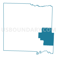
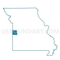
Hudson Voting District, Bates County, Missouri
About
Outline

Summary
| Unique Area Identifier | 607097 |
| Name | Hudson Voting District |
| County | Bates County |
| State | Missouri |
| Area (square miles) | 76.72 |
| Land Area (square miles) | 76.09 |
| Water Area (square miles) | 0.62 |
| % of Land Area | 99.19 |
| % of Water Area | 0.81 |
| Latitude of the Internal Point | 38.18462450 |
| Longtitude of the Internal Point | -94.13225520 |
Maps

Graphs
Select a template below for downloading or customizing gragh for Hudson Voting District, Bates County, Missouri


Neighbors
Neighoring Voting District (by Name) Neighboring Voting District on the Map
- Appleton No. 1 Voting District, St. Clair County, MO
- Appleton No. 2 Voting District, St. Clair County, MO
- Ballard Voting District, Bates County, MO
- Bearcreek / Deepwater Voting District, Henry County, MO
- Butler No. 1 Voting District, Bates County, MO
- Butler No. 3 Voting District, Bates County, MO
- Rich Hill North Voting District, Bates County, MO
- Rockville Voting District, Bates County, MO
- Taber Voting District, St. Clair County, MO
Top 10 Neighboring County Subdivision (by Population) Neighboring County Subdivision on the Map
- Appleton township, St. Clair County, MO (1,401)
- Deepwater township, Henry County, MO (573)
- Summit township, Bates County, MO (312)
- Deepwater township, Bates County, MO (307)
- Rockville township, Bates County, MO (260)
- Hudson township, Bates County, MO (252)
- Pleasant Gap township, Bates County, MO (232)
- Taber township, St. Clair County, MO (190)
- Prairie township, Bates County, MO (137)
Top 10 Neighboring Elementary School District (by Population) Neighboring Elementary School District on the Map
Top 10 Neighboring Unified School District (by Population) Neighboring Unified School District on the Map
- Butler R-V School District, MO (6,338)
- Rich Hill R-IV School District, MO (2,572)
- Appleton City R-II School District, MO (2,330)
- Ballard R-II School District, MO (867)
- Montrose R-XIV School District, MO (795)
Top 10 Neighboring State Legislative District Lower Chamber (by Population) Neighboring State Legislative District Lower Chamber on the Map
Top 10 Neighboring State Legislative District Upper Chamber (by Population) Neighboring State Legislative District Upper Chamber on the Map
Top 10 Neighboring 111th Congressional District (by Population) Neighboring 111th Congressional District on the Map
Top 10 Neighboring Census Tract (by Population) Neighboring Census Tract on the Map
- Census Tract 701, Bates County, MO (5,248)
- Census Tract 4801, St. Clair County, MO (3,671)
- Census Tract 9504, Henry County, MO (3,027)
- Census Tract 4802, St. Clair County, MO (2,952)
- Census Tract 704, Bates County, MO (2,870)